
Solar radiation map
|
|
|
Average monthly mean solar radiation over the Iberian Peninsula in March. Map values are given in kWh/m². In these maps values are optimized for every month, taking into account direct radiation, solar path, shading, diffuse radiation and horizon obstruction. |
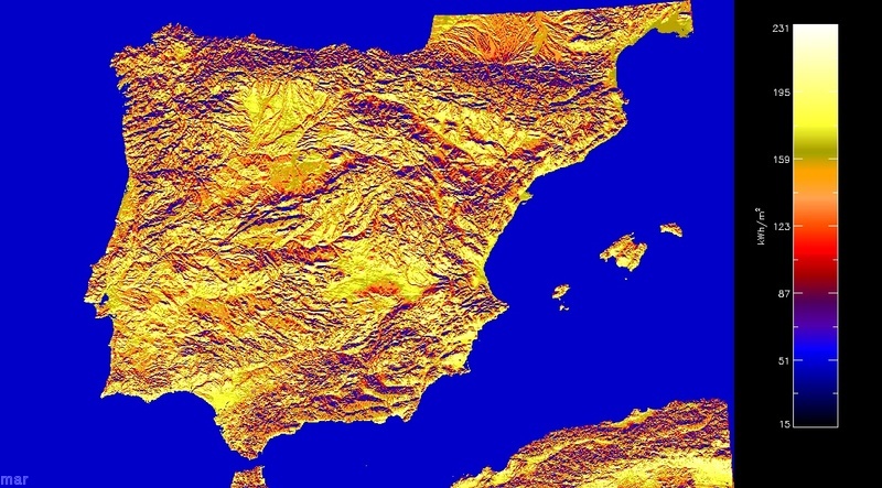
This map shows the monthly mean of maximum potential insolation received at the surface. Insolation is computed for clear skies, without clouds. Computation is based on Bird & Hulstrom (1981) parametric model modified by Iqbal (1983) with updated solar constant. This model computes direct and diffuse radiation, and takes into account atmospheric attenuation due to transmittances of water vapour, aerosols, mixed gases, ozone and Rayleigh scattering. The models takes into account increased transmittance with elevation. Humidity and temperature parameters have been chosen according to mean values from the las 50 years of NCEP/NCAR reanalisys data for the corresponding grid. To compute the angle between the solar vector and the vector normal to ground and the effect of surrounding topography Corripio's (2003b) model was followed. The effect of terrain on hemispheric view obstruction and its impact on diffuse radiation is incorporated through a skyview factor. Topography is derived from the USGS GTOPO30 digital elevation model (DEM) reprojected on UTM and interpolated to a regular squared grid at 900 m resolution. The chosen model is one of the best performing models in a comparative study by Niemelä and others (2001).
For higher resolution studies we also use the ASTER GDEM at 30 m or high resolution lidar or photogrammetry DEMs, together with land cover maps that permit the evaluation of surrounding terrain on reflected diffuse radiation. This effect is especially important in winter due to the high albedo of the snow. These studies also incorporate information on cloud cover, Linke atmospheric turbidity, land use and weather and climatic data from global and mesoscale models.
For a more detailed description of the radiation model you can download this document from Corripio, 2003a: "Modelling the energy balance at the surface" (1.5 MB).
Cited references:
- Bird, R. E. and Hulstrom, R. L.: 1981a, Review, evaluation and improvements of direct irradiance models, Trans. ASME J. Solar Energy Eng. 103, 182–192.
- Bird, R. E. and Hulstrom, R. L.: 1981b, A simplified clear sky model for direct and diffuse insolation on horizontal surfaces, Technical Report SERI/TR–62–761, Solar Research Institute, Golden, Colorado.
- Corripio, J. G.: 2003a, Modelling the energy balance of high altitude glacierised basins in the Central Andes, PhD Thesis, University of Edinburgh. pdf (12.1 MB)
- Corripio, J. G.: 2003b, Vectorial algebra algorithms for calculating terrain parameters from DEMs and the position of the sun for solar radiation modelling in mountainous terrain, International Journal of Geographical Information Science 17(1), 1–23. pdf
- Iqbal, M.: 1983, An Introduction to Solar Radiation, Academic Press, Toronto.
- Niemelä, S., Räisänen, P. and Savijärvi, H.: 2001b, Comparison of surface radiative flux parameterizations. Part II: Shortwave radiation, Atmospheric Research 58, 141–154.